Paper to CAD drafting services, Architectural Maps, Mechanical & civil maps, Machine Drawings, Historical Archives, Construction documents
DimensionI CAD: Paper to CAD drafting Services Dimensioni
Home About Us Services Portfolio Procedure Guarantee Career Contact Us FAQs


SERVICES
Paper to CAD
CADD
2D
3D
GIS
Utility Mapping
Remote Sensing
AM/FM
Thematic Mapping
Contour Mapping
Parcel Mapping
Topographic Mapping
Image Processing
Gis Application Development
GIS Applications
  » Services > GIS > Environment GIS
Rural GIS   |   Health GIS   |   Municipal GIS   |   Disaster Management
Environment GIS   |   Transport GIS   |   Geology Mapping
Urban GIS   |   Facility Management   |   Business GIS Solutions

Environment GIS

There is clearly a need for improved information on levels of traffic related air pollution. This information is required for a wide range of purposes:

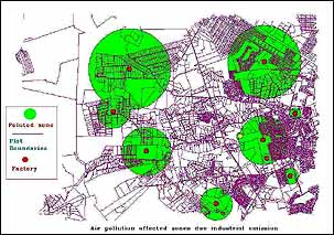
  • To help investigate the relationship involved as inputs to health risk assessment, to assist in establishing and monitoring air quality standards, and to help evaluate and compare transport policies and plans.
  • For all these purposes information is required not only on temporal trends in air pollution but also on geographic variations.
  • GIS based vehicular pollution models are needed to identify pollution hot spots, to define at risk groups, to show changes in spatial patterns of pollution resulting from policy or other interventions
  • To provide improved estimates of exposure for epidemiological studies.

« Back

DimensioniCAD - India's premier CAD & GIS services company.
Paper to CAD drafting services, Architectural maps digitisation India, Outsource microstation drafting work to India