Paper to CAD drafting services, Architectural Maps, Mechanical & civil maps, Machine Drawings, Historical Archives, Construction documents

Municipal GIS

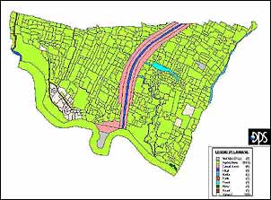
Land information is crucial for planning and development. The rapid pace of development in many of the Municipalities in India.
municipal-gis

  • While bringing high growth rates also brings with it heavy burdens on land utilization.
  • To ensure that the high growth rates can be sustained, it is imperative to plan for an effective Land Information system to plan the utilization of its land resources for development while at the same time protect the environment.
  • The department can minimize vexatious boundary disputes and consequently civil litigation can efficiently safeguard the survey framework on ground.
  • Since the numeric data of each Survey Field is computerized, the maps generated by the computer area, without exception, for more accurate than the maps available at present and can function as efficient decision making tool.

What's Next

We would love to hear about your next project

Please write to us at sales@dimensionindia.com


captcha


Have your any question
  • Can I get a free sample & price / time quote?
  • How and when do we communicate?
  • What is the turnaround time?
  • Do you have customer references?
  • Do I pay per hour, per project or per person?
  • How and when do I pay?
We have the answers.
Email at sales@dimensionindia.com

Dimensioni- India's premier CAD services & solutions company.
CAD drafting services, CAFM BOMA Polylining services, microstation drafting, architectural CAD outsourcing, seo india

Dimension India is the world's leading CAD services provider to Companies, AEC firms, real estate companies and municipal governments. The company serves its customers all over the globe through its offices in New Delhi. Our services are best-in-class and are backed by glowing customer references. Please feel free to get in touch for a discussion.