Golf Course Mapping Services


Dimensioni brings digital mapping and geospatial services to the golf and sports industries. The mapping enables the Golf course owners, users and architects to view their sites from two and three dimensional perspectives. We provide mapping services to the golf and sports industry via our partners in offshore locations. Dimension India solutions includes: • Digital Golf Course Mapping • Topographic Mapping
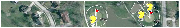
We have worked some of the leading US companies dealing in the golf and sports industries and mapped more than ten thousand golf courses which are of 9, 18, 27, 36, 45 and 54 holes. This involves capturing of Club house, Tees, Greens, Fairways, holes, sand trap, water bodies etc. The base maps that we have used to map these Golf courses are obtained from substantially lower-cost existing aerial photos and satellite imagery. We have worked on different format of the imagery like JPG, SID, ECW, TIF etc. We can convert the imagery also from one format to another if required. The output files provided can be of different format viz. DWG (CAD), Shape, DGN etc. The objective of developing this dataset is to create mobile GPS application to demonstrate how mobile technology can be applied to place of play and ultimately to assist those players and course managers address the problem of slow play and its resulting conflicts that the Golf Industry is facing today.
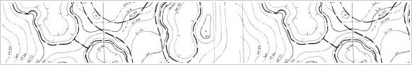
We are working on Golf Course contour mapping as well which involves the capturing of contour lines and place the corresponding elevation as an annotation in Bentley‘s Micro station. The base maps used is a white background TIF file that needs to be digitized on the pre-specified layers. The objective is to show the topography of the course that can be helpful in the planning, design work and construction controls.
We have got enough experience in this Golf-Course mapping services and are equipped to handle any volume of work within a predetermined time frame and faster turnaround with high quality standards. Our mutual beneficial and cost effective service in India has shown a significant effect on our customer’s businesses. This is also one of the reason we being the preferred choice of our customers.
The key behind our success and our client’s satisfaction thus far is our Quality. We have a quality management system in place applicable for all the projects we have executed so far. It not only facilitated the company but it also provides a confidence to our customers. Our main focus is on the quality control and quality assurance of the final product being delivered to our client. We always put in place two to three layers of quality check in order refine our product depending upon the size and duration of the project.
We are flexible and can work on Customized built in application also. This is because we are fast learners and can adopt any kind of application or technology based on the client’s or project requirements. We have a team of qualified professionals who have got experience in different softwares and domains in the IT industry. We can execute no obligation pilot project in order to exhibit our technical capabilities and service standards if required.
Our services are best-in-class and are backed by customer references. Please click here to get in touch for further details, it would be worth the time.