Paper to CAD Services


We offer complete Paper-to-CAD Conversions and CAD Drafting Services at competitive prices with the precision and quality you can depend on. however easy it may sound, conversion can be difficult. The ability to accurately capture old, smudged and dense information comes only after years of experience and processes which ensure that the output is accurate.
 |
|
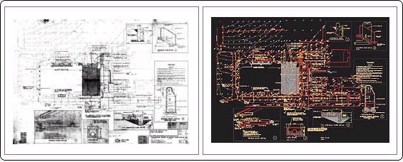
| Input | Output |
We utilize the latest standards and techniques to develop your CAD projects. Having your original documents converted to CAD enables you to store your files in a more organized and efficient manner, giving you greater flexibility and increasing productivity. We convert all types of drawings. be it mechanical, architectural, electrical, structural, plumbing, maps, parcels etc., we have skilled draftsmen working under domain experts to convert with consistency and diligent quality control.
Once the first project is completed successfully, we will ensure that our simple knowledge management system manages your specifications and standards across operators and managers and ensure that the files are of consistently high quality.
Paper to cad process
Our methods of Raster to Vector Conversion:
- We always maintain the actual dimension of the drawings.
- We always do rubber sheet to the raster to make the dimension accurate.
- We always try to keep the layers specified by our clients, otherwise we do that by our layers.
- We can maintain international standards.
- We can maintain snap on/off, grid on/off, dimaso on/off on your drawings.
- We can use standard blocks and attributes on your drawings.
- We can convert your paper drawings maintaining ID points.
- We can convert your paper maps by poly line/L.F.X. method.
- We can convert your paper maps by poly line arc method, taking only 2nd points and plines.
- All cad files are plotted and checked by our efficient checkers before sending you the final copy.
Large Format Scanning & Raster to Vector Conversion
Today’s economic climate creates a tremendous challenge to engineers, facilities managers, architects and others in design driven fields that have to manage and organize an increasing volume of large and specialty size documents, and at the same time control costs. Not only do you have to archive and store a vast array of document types, but you are also faced with managing technical documentation and revisions, reproducing old maps and charts, merging paper documents into CAD systems and integrating other types of essential documentation together into one computing environment.
Computers continue to play a pivotal role in all design driven fields. CAD systems databases, spreadsheets, word processors and related applications have all but replaced traditional paper documentation methods. Many companies are turning to scanning technology to quickly enter this information into their computer systems so it can be shared, organized and managed.
Most organizations realize the benefits of imaging instantly, such as
- Reproduce superior quality drawings from poor quality originals.
- Save time vs. digitizing tablets, redrawing, copying and printing documents.
- Conversion from raster formats to 100% CAD perfect geometry.
- Enhanced service to clients at a lower cost.
- Increased productivity and control.
- Eliminate misplaced drawings and documentation.
- Shared access to large files and databases
Convert to any type of file format
- CCITT Group IV
- TIFF Group IV
- JPEG
- CALS
- RLC
- PCX
- Intergraph
- DWG
- DXF
Conversion into popular software programs
- AutoCAD
- Arc InfoCad
- ArcView
- MapInfo
- Intergraph
- Microstation